


Douglas City Hall, Marshall County, Alabama
About
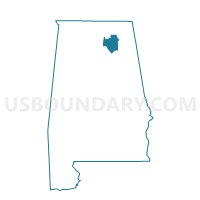
Outline

Summary
| Unique Area Identifier | 522471 |
| Name | Douglas City Hall |
| County | Marshall County |
| State | Alabama |
| Area (square miles) | 8.15 |
| Land Area (square miles) | 8.14 |
| Water Area (square miles) | 0.01 |
| % of Land Area | 99.82 |
| % of Water Area | 0.18 |
| Latitude of the Internal Point | 34.18510870 |
| Longtitude of the Internal Point | -86.34672950 |
Maps


Graphs
Select a template below for downloading or customizing gragh for Douglas City Hall, Marshall County, Alabama


Neighbors
Neighoring Voting District (by Name) Neighboring Voting District on the Map
- Douglas City Hall, Marshall County, AL
- Douglas City Hall, Marshall County, AL
- Nixon Chapel Fire Dept, Marshall County, AL
- Pine Grove School A-D, Marshall County, AL
- Snead, Blount County, AL
Top 10 Neighboring County Subdivision (by Population) Neighboring County Subdivision on the Map
- Douglas CCD, Marshall County, AL (6,028)
- Clarence CCD, Blount County, AL (5,269)
- Brooksville CCD, Blount County, AL (4,451)
Top 10 Neighboring Place (by Population) Neighboring Place on the Map
Top 10 Neighboring Unified School District (by Population) Neighboring Unified School District on the Map
Top 10 Neighboring State Legislative District Lower Chamber (by Population) Neighboring State Legislative District Lower Chamber on the Map
Top 10 Neighboring State Legislative District Upper Chamber (by Population) Neighboring State Legislative District Upper Chamber on the Map
Top 10 Neighboring 111th Congressional District (by Population) Neighboring 111th Congressional District on the Map
Top 10 Neighboring Census Tract (by Population) Neighboring Census Tract on the Map
- Census Tract 310, Marshall County, AL (6,028)
- Census Tract 503, Blount County, AL (5,269)
- Census Tract 504, Blount County, AL (4,451)